The Flight Log. Every flight the Streamer recorded, with what the link and the aircraft were doing at the time.
Every time you fly, Cosmik Streamer quietly writes down how things were going — once a second, for the whole flight. How strong your control link was. Whether the picture held up. What your battery was doing, if your drone tells it. Where you were, if your drone has GPS.
The Flight Log is where you look at all of that afterwards.
There is nothing to switch on. It has been doing this since the day you set the box up.
Why you'd bother
Because "the signal felt dodgy over by the trees" becomes "the link dropped to 22% at 4 minutes in, and here's the video of exactly what I was flying past".
That's the difference between a hunch and something you can plan a shoot around. Fly the same venue again and you already know where not to go.
The timeline does not require GPS. Most freestyle quads don't have it, and a lot of good flying happens indoors where GPS doesn't work anyway — which is exactly where a patch of bad signal costs you the most. The Flight Log is built around time, not position, so it works everywhere. If your drone does have GPS, you get a map of your path as a bonus.
Finding it
Console → Flight Log.
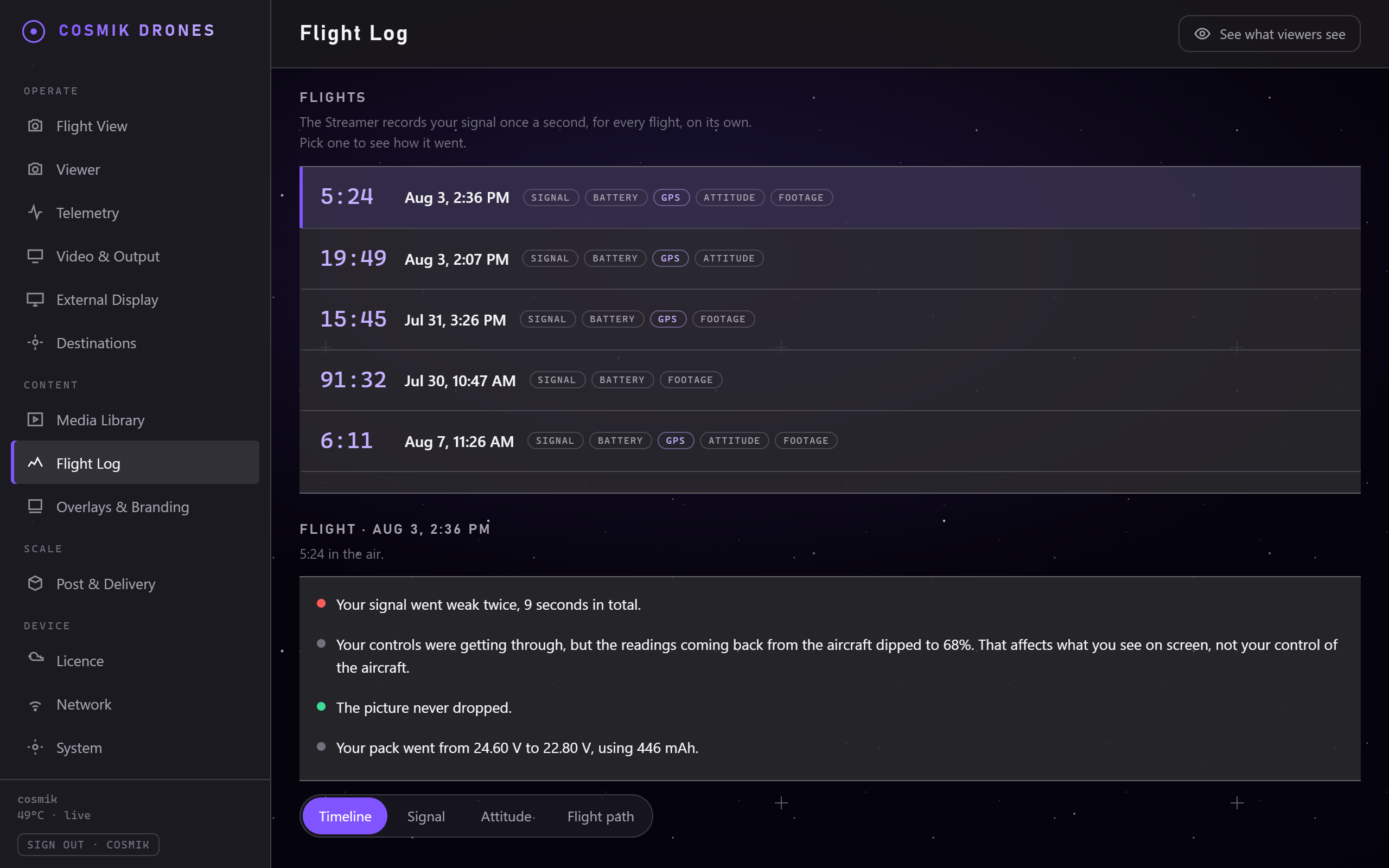
Your flights are listed newest first, with the date, how long you were in the air, and small tags saying what that flight has in it — Signal, Battery, GPS, Attitude, Footage. Tap one to open it. The newest flight opens on its own.
What counts as "a flight"? The box starts a flight the moment your video feed or your radio comes up, and finishes it a minute after everything has gone quiet. So a battery change gives you a new flight, and a brief dropout doesn't.
What it tells you
The plain-English summary
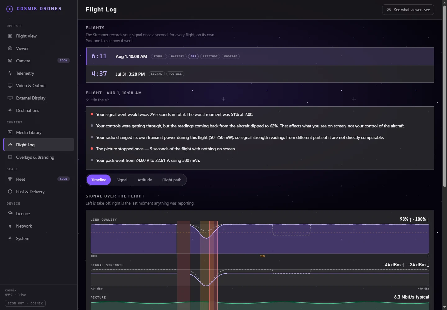
At the top of every flight is a short list of what actually happened, in sentences:
If nothing went wrong, it says that too. That is the useful answer most days.
The chart — the Timeline
Underneath is the flight drawn out from left to right — take-off on the left, the last moment anything was reporting on the right.
| Lane | What it shows |
|---|---|
| Link quality | The one to watch. 100% is perfect; the dotted line marks 70%, below which it's worth noticing. |
| Signal strength | The raw strength in dBm. Closer to zero is stronger. |
| Picture | How much video was flowing, and where it stopped. |
| Battery | Your pack's voltage over the flight — only if your flight controller reports it. |
| Footage | Gold blocks showing when a recording was actually running, so you can see which parts of the flight you can watch back. |
Trouble is shaded straight across every lane, so one glance finds it. Amber is a weak link; red is the picture stopping.
Move your finger or mouse across the chart and every lane tells you what it read at that exact instant, with a line underneath saying what it means.
Two lines, not one. A solid line is the uplink — your sticks reaching the aircraft. A dashed line is the downlink — everything the aircraft says coming back to you. They are two different radios and they can fail separately: it is normal to see your controls getting through perfectly while the readings coming back go patchy. Only the uplink affects your control of the aircraft.
A break in a line means "nothing reported this", never "the reading was zero". If your radio went quiet for nine seconds, there is a nine-second hole in the line. The Streamer will not draw a line straight through a moment nobody measured, and it will never plot a missing reading as zero. If your drone never sent a battery voltage at all, there is no battery lane — the box will not invent one.
The Signal view
The Signal tab is the same flight told as a radio report, for when a flight felt marginal and you want to know exactly which part of it was.
- Six headline figures: link quality and signal strength in both directions, the noise margin (how much room the signal had above the background before it started losing packets), and the transmit power your radio was actually using.
- Four charts, one for each — uplink and downlink separated so you can see which one struggled.
- Where it got worst — the lowest moment of each reading, with its time in the flight and a button straight to the footage.
If your radio changed its own transmit power mid-flight, the page says so. ExpressLRS turns its power up and down on its own, and when it does, a weaker signal reading may only mean the radio backed off rather than that you flew further away. Two readings from that flight are not directly comparable, and the page tells you rather than letting you draw the wrong conclusion.
The Attitude view
The Attitude tab draws pitch, roll and yaw over the flight — which way the aircraft was pointing, as opposed to where it was. Nose up is a positive pitch, and the top of the tab shows your steepest climb, steepest dive and widest roll.
Move across the chart and the values appear right on the lines at that moment. Scroll (or pinch) to zoom into a moment, drag to slide along the flight, and a small overview strip appears under the chart showing where you are — drag it to move, or double-tap (double-click) to see the whole flight again. Tap to pin a moment: the reading stays put, and if footage was rolling there, a Watch this moment button takes you straight to it.
The yaw lane counts turns rather than pointing at a compass. It starts at the heading you took off on and keeps adding, so four circles to the left read as a line sloping steadily downwards instead of four jumps across the chart. The labels underneath say how far round you were at each end of the scale — "4.1 turns left" — and the middle mark is the heading you took off on, so every time the line touches it you were facing the way you started. Hover anywhere and the reading is still the compass heading at that second.
Why not a compass dial? Because a compass has to jump from 180° back to −180° every time you turn through the back, and a pilot who spins the aircraft would get a chart full of vertical lines that look like faults instead of flying. Counting the turns keeps the line honest and readable. Where readings are missing, the lane assumes you took the shorter way round.
A break in any of the three lines still means only one thing: the flight controller did not report at that moment.
Flights recorded before 31 July 2026 do not have it. The Streamer only started saving attitude on that date, so older flights say "No attitude was recorded on this flight" rather than drawing three flat lines. Nothing is wrong with your aircraft. It needs your flight controller to be sending telemetry over your ExpressLRS link, the same as battery does.
Moments worth a look
Below the chart is every moment the Streamer noticed, in order, in plain language — "Link quality fell to 22% for 9 seconds".
If a recording was running at the time, there's a "Watch this moment" button. Press it and the Media Library opens that recording at that point, so you can see what you were flying past. That is the whole point: the numbers tell you when, the video tells you why.
The flight path — for drones with GPS
If your aircraft recorded its position, a Flight path tab appears next to the summary.
One map, not two. There used to be a separate Replay tab showing the same flight a second time. It has gone, and everything worth having from it — choosing what the colour means, following the aircraft, and the strip under the picture — is on the flight path now.
At the top is a switch with two settings, and that is the only choice you have to make:
| Setting | What you get |
|---|---|
| 3-D | Your flight as a solid ribbon in three dimensions, over a grid. This is what it opens on. |
| Flat map | The same track drawn flat and top-down, to scale, with a scale bar in metres. |
Flat map is also what appears automatically if your phone's browser can't show 3-D, or if the flight has too few positions to build a scene from.
Reading the 3-D view
The path is drawn as a ribbon over a grid, with a ring marking where you launched and N showing which way north is. A faint curtain hangs from the path down to the ground so you can see height at a glance; the Curtain button at the top right turns it off and on.
As the flight plays, a glowing trail follows your aircraft along the path — brightest right at it, fading out behind over the last few seconds — so you can see which way it was going and how fast it covered ground, even on a tangled path. Scrub the timeline and the trail follows your finger. The Trail button turns it off and on.
Press ▶ and a glowing dot flies your flight — drag the slider, or drag anywhere on the strip underneath the picture, to move it. Turn Follow on (top right) and the view travels with your aircraft instead of staying put; moving the view by hand turns it off again.
Whenever footage was rolling at the moment you are sitting on, a Watch this moment button appears in the readout box in the top-left corner. Scrub the strip to the bit you want to see, press it, and the Media Library opens that recording at that second. You do not have to find the exact point on the path first.
The small aircraft symbol shows which way the nose was pointing, taken from your flight controller — not the direction it happened to be drifting. That matters most when you are hovering or sitting on the ground, where there is no direction of travel to read: the symbol holds still, because the aircraft was holding still.
Most FPV aircraft carry no compass, so the flight controller measures the nose against whichever way it was facing when you powered up. The Streamer works out the difference for you from your fastest, straightest legs of the flight, where the nose and the track agree. If a flight never had one — a pure hover, say — the note under the picture tells you so, and you should read the symbol against take-off rather than against north.
Choosing what the colour means
Under the picture is Colour by, and it changes what the whole path is telling you. Only one at a time, so there is never a second meaning on screen to confuse it with:
| Colour by | What the ribbon shows |
|---|---|
| Altitude | How high you were above your launch point. This is what it opens on. |
| Signal | Link quality — your controls reaching the aircraft. |
| RSSI | Raw signal strength, in dBm. |
| Speed | How fast you were moving across the ground. |
| Battery | What was left in the pack. |
Dark is the low end of whatever you picked and near-white is the high end, and the label in the bottom-right corner always states the two ends in real numbers — for the flight you are looking at, not some general scale. A flight where the signal never left 97–100% will still show the full range of colour; the label is what tells you the whole spread was three percent. The strip underneath changes to match, so you can see when it happened as well as where.
If your aircraft never reported one of them, that button says so rather than pretending — it is greyed with a small dash, and hovering it explains why. Where a reading is missing for part of a flight, the path goes plain grey there. Missing is never drawn as zero.
What the markings mean
Only the moments that matter are marked. A five-minute flight has hundreds of recorded positions, and putting a dot on every one of them made a cloud you couldn't read or tap. So the Streamer marks where something changes — usually a handful of rings on the whole flight — and lets the ribbon carry the rest. You can still tap anywhere on the path to read that moment; the rings are simply the ones worth looking at first.
| Ring | What it means |
|---|---|
| Gold, filled | A recording starts here — this is a part of the flight you can watch back. |
| Amber, filled | Your signal went weak here. |
| Red, filled | The picture or the radio dropped here. |
| Amber, hollow, on the ground | A height reading that was an obvious glitch, shown where it happened instead of being drawn as a dive into the earth. |
| Violet, hollow, on the ground | You were at — or below — your launch height. Your flight controller can't report a height under the launch point, so those moments read 0 m, and the ring is the honest hint that "0" may really mean "a little below where you took off". |
Tap or click a ring — or anywhere on the path — to read that moment: time, height, speed, signal. If a recording was running, a Watch this moment button takes you straight to the footage. The rings are deliberately generous targets, so a fingertip lands on one first time.
Two more things the ribbon itself tells you:
- Ghosted (see-through) stretches mean the height there is estimated: GPS briefly couldn't measure height reliably, so the Streamer filled the gap between the clean readings either side and dimmed it rather than pretending.
- Dashed straight lines bridge moments where positions stopped arriving — nothing is invented across a gap.
Moving around it
- Drag with one finger (or the mouse) to orbit around the flight.
- Pinch with two fingers to zoom; move both fingers together to slide the view. On a computer, scroll to zoom and hold Shift while dragging to slide.
- Double-tap (double-click) to see the whole flight again.
- The ⟲ ⟳ − + ⌂ buttons in the corner do the same — rotate, zoom, and reset — and the arrow keys work too, if a keyboard is easier for you.
There is no map underneath either view, and that's deliberate. Map backgrounds have to be downloaded from the internet, and the whole idea of this box is that it makes its own Wi-Fi so you can fly in a field with no signal. A map that worked at home and was blank at the shoot would be worse than none. The 3-D scene's grid is labelled in real metres, and the flat map has a scale bar — real distances, no internet.
No GPS module on your quad? Then there is no flight path, and the Flight Log says so plainly rather than leaving you waiting for it. Everything else on the page works exactly the same.
About height
The height your aircraft sends isn't a raw GPS number — it is your flight controller's own height estimate, and from the moment you arm, that estimate means height above your launch point. That is exactly the number a pilot wants, and it is what the flight path draws — the 3-D view and the flat map read the very same cleaned-up data, so they can never disagree. Three honest quirks, all shown rather than hidden:
- Below launch reads as 0. Your flight controller cannot report a height under the launch point — dive below it and the number sits at 0 m until you climb back. Those moments are marked with small violet rings so "0" is never mistaken for "exactly at launch height".
- Time parked shows at ground level. Before you arm and after you land, the aircraft reports the field's height above sea level instead — so the Streamer draws parked time at the ground, where it belongs, rather than as a phantom cliff.
- Obviously-broken readings still happen (a height that leaps by a hundred metres for one moment and snaps back). They are shown as small amber rings at ground level, so you can see they happened without them being drawn as flying.
Two more cases the Streamer handles on its own:
- If your flight controller has a barometer, the Streamer uses it for height automatically. A barometer reads height to well under a metre, and most flight controllers have one.
- If a flight never shows the arm-time switch in its numbers (rare — for example the log started mid-flight), the Streamer falls back to measuring how noisy this session's GPS readings were and says so on the page (for example "heights from GPS, ±17 m this session"). A low hop inside that noise is drawn flat at ground level — with a sentence explaining why — rather than as imaginary hills.
What each part needs
| Part of the Flight Log | Needs |
|---|---|
| The flight list, timing, picture and dropouts | The Streamer's own session and picture data. The exact device-served interface has been captured with the repository fixture; authenticated real-flight data remains in Validation until its current-device walk-through is complete. |
| Link quality and signal strength | An ExpressLRS radio with its backpack set up — see Signal & Telemetry |
| Battery voltage and mAh | Your flight controller sending telemetry |
| The flight path | A GPS module on the aircraft |
| Precise height on the flight path | A barometer on the flight controller (most have one) |
| "Watch this moment" | A recording to have been running at the time |
Housekeeping
- Only you can see this. The Flight Log sits behind your console password, like your recordings. Guests watching your live view cannot reach it — which matters, because on a GPS-equipped drone it is a record of where you were and when.
- Flight-log storage is counted. The System page includes it in the storage figures. No public capacity figure is claimed here before release measurement.
- Shut it down from the console rather than pulling the plug. System → Power off closes everything down properly so the card is never at risk. Give it ten seconds, then unplug.
- If the power is cut mid-flight anyway, the last second or so of the log can be cut off. The flight still opens, everything before it is intact, and the page tells you it happened.
- On a long flight the chart shows a selection of the readings rather than all of them — but it always keeps the worst reading in each slice, so a dropout can never be smoothed away.
Source: /docs/flight-log.md